RT by @Copernicus EU: This year Greece recorded the highest wildfire emissions for September in our #CopernicusAtmospheredataset (since 2003). The fire radiative power chart shows the exceptional intensity of the fires in the last days. Check our dataset: [2024-10-01 13:13 UTC]
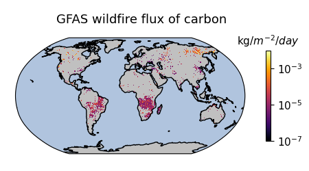
 image
This https://nitter.privacydev.net/search?q=%23Sentinel2 image shows the Guadiana Estuary on the border of 🇵🇹and 🇪🇸, where the Guadiana River meets the Atlantic Ocean. The region is rich in biodiversity, with wetlands, salt marshes, a variety of fish and bird, and over 460 recorded plant species. [2024-10-01 07:36 UTC] image
The https://nitter.privacydev.net/search?q=%23CopernicusMarine https://nitter.privacydev.net/search?q=%23OceanStateReport 8 has just been published 🌊 ➡️Important findings include that 2023 saw the lowest sea ice levels on record in the polar regions 🧊 Read more at👇 [2024-09-30 12:22 UTC] image
https://nitter.privacydev.net/search?q=%23Copernicus https://nitter.privacydev.net/search?q=%23OpenData 🛰️supports actions to protect and preserve our oceans and marine ecosystems 🌊 Explore this topic during the 2⃣nd webinar of the EU 🇪🇺 https://nitter.privacydev.net/search?q=%23OceanData series! 🗓️10 October 🕑14:30 CEST Register now 👇 [2024-09-30 11:59 UTC] image
This https://nitter.privacydev.net/search?q=%23Sentinel2 image shows a depleted Lake Tefé in northwestern Brazil. The city of Tefé, located along the Solimões River is also visible. This part of the Amazon Basin is currently facing record-low water levels due to an unprecedented drought. 🔗 [2024-09-30 07:42 UTC] image
Flooded areas along the Mekong River in Cambodia are shown in this image acquired by one of our Sentinel-2 satellites on 26 September 2024. The areas around Krouch Chhmar and Chumnik, visible in the image, are heavily affected by the flooding. [2024-09-28 09:25 UTC] image